 |
| The Tay reedbeds near Powgavie |
 |
| Purple paths designated "core" by Perth and Kinross Council |
 |
| My route, anticlockwise from A, on the road just south of Powgavie |
There are other photos of this walk on
Instagram.
This walk is in the Carse of Gowrie which is essentially the western side of the river Tay's floodplain between Perth and Dundee. It is a flat, fertile zone famous for soft fruit. It extends westwards for four or five miles until it reaches some low hills, the Braes of the Carse.
Dundee, the Carse and even Blairgowrie receive significantly more sunshine than Perth which, according to Anchor Pumps, is number 7 in the UK's top ten
greyest cities. I explore the Carse quite often because it's not far and even an hour or two of sunshine, even a streak of blue sky can tranform a day for me in the long dark Scottish winters. I rarely meet people there.
The Errol circular aside, none of the Perthshire's most well-known walks are in the Carse. Given its sunshine and its braes, this is a shame. Another issue is that there are few obviously circular walks on core paths. Most walkers I know or meet like to do a circular rather than a linear walk.
I'd been to scout parking at Powgavie before Christmas & walked a field's length east. I wanted to walk up to Templehall this time and back on a circular route.
Unusually, the promised sun on this day did not materialise, but the day was still and the Tay was like glass. It was very peaceful. This walk is all about big skies, miles of reedbeds, fine views of the Fife coast, the Braes of the Carse and the Sidlaws. I could even make out buildings in Dundee and the bridge across the Tay. I heard deer on the reedbed fringe below the track, then watched the white rump of an elegant roe disappear ahead of me. The reedbeds are famous for rare birds. Being no ornithologist and focused on the route I noticed that hedgerow birds were abundant even on this chilly day, saw a heron, greylag geese and heard the high, whistling call of redshank. Both times I've been here beside the Tay I have met no-one.
Parking is often the main issue I find in the Carse and again I found no easy parking at Powgavie nor around Templehall which is the other end of this walk shown above. I drove past Powgavie farm and parked on the fairly wide verge some distance from where the road ends (at a house). I am no fan of verge parking and rarely do it but could find no other options. When a core path is not near a village and has no designated parking what else are you supposed to do? Because of parking and access issues on core paths themselves I have sometimes wondered if the creation of some of them is more an administrative tickbox exercise than a walking reality.
My (obvious) rules of thumb for verge parking are:
- don't block field entrances
- don't inconvenience residents
- could a fire engine get past?
There were no green core path signposts on any of this walk.

Per a zoomed view of the core path on the interactive map, it lies just north of the fence line. Reassuringly, the field has not been ploughed right to the hedge.
However, this would be a dull walk with views of the reeds and the river blocked by a hedge. This walk is all about the views on the riparian side of the hedge and they are mostly on this first section. I wouldn't bother doing this walk just to walk along the field.
At the end of the paddock adjoining the house, people before me had clearly gone through the middle of a relatively easy fence to get to a faint path on the other side of the hedge where the views are. Obviously having to cross the fence to walk the path with the views is not ideal.

At about the end of the first field is a very tricky stile. The tall post to help you get up is loose and can't be used as such which makes mounting the stile more difficult than it looks. Another post is broken, the whole thing is rickety and dangerously festooned with barbed wire and rusty nails. It was narrow for the dog to squeeze through the tearing spikes of that cruel invention that is so liberally and viciously cast right across our countryside. I thought I was reasonably fit but it wasn't easy to surmount. If you have hip or similar mobility problems, I think your chances of having to return are high.
Soon there is a small burn. The choice is a marshy crossing or to clamber down quite a steep, rocky bank. I took the latter option. Again, with any mobility issues this would be tricky.
Thereafter, just below Kingston farm, the "core path" is along the field edge. Only
, there is no path visible and the field is sown right to the edge of the bank leading down to the reed beds.
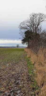
A little further at an attractive bend there are one or two magnificent ?Scots pine trees. Views are regained. But the rest of the walk is flat, treeless, uninteresting and unwelcoming (see below) and has a significant section of road. If I walked by the reedbeds again, I would probably turn back at this tree.
Along the field edge was slow going, even on the hard ground so I moved on to some vehicle tracks a little further in.
The field ends at a gate. Go through this to find a dog-legged cinder track. This passes some paddocks, then some houses. At the red dot I noticed an incorrect sign right on the core path: "No public right of way". It is also illegal to place clearly deterrent notices like this.
On the other side of the track another sign indicates who lives here There is then a long straight road section back. It is marked on OS maps with green dots which according to the OS means "legally protected routes that the public may use by foot". I'm not sure what that means for a walker on the ground but the fact is the road is very fast. There were one or two careful and considerate drivers but most drove with indifference to walkers and too quickly. A couple of boys drove at motorway speeds.
A woman walking ahead of me eventually turned around and walked back. I hoped this wasn't all she had for a regular walk. I asked if she knew about the no public access sign. She didn't and said she had always been put off from walking there by the sign. This will almost certainly be the case for most people. I told her about the core path and the online interactive map.
Next is a left turn down to Kingston farm and a level crossing which is not locked. From there it is a barren, flat & treeless return to Powgavie.
Powgavie farm has as a weirdly crenellated silo for which I have no explanation. According to Maurice Fleming's
The Sidlaws: Tales, Traditions and Ballads, Powgavie at one time had a shapeshifting witch called Jenny Gairie. Did she live in the atmospheric and apparently abandoned cottage opposite the farm...?
Update: 12.03.21 - I have reported the sign issue to one of those representing walkers on the The Perth & Kinross Outdoor Access Forum.


No comments:
Post a Comment